Where Did the Middle East Go? Satellite Imaging in the Fog of War
Planet Labs’ decision to restrict Middle East satellite imagery is raising questions within a multibillion-dollar industry about commercial independence and global accountability.
Planet Labs PBC, a satellite imaging company founded in 2010, has more than 200 satellites that photograph Earth’s entire landmass every day, a frequency unmatched by the rest of the industry. Although most of its competitors sell isolated images on demand, Planet operates more like an open streaming service, allowing customers—which include commodity traders, governments and humanitarian organizations—to download, publish and build on top of its data.
Recently, for a large part of the globe, that operation stopped. On April 5, Planet announced to customers that the US government had requested that all satellite imagery providers “voluntarily implement an indefinite withhold” of imagery retroactive to March 9 across a broad swath of the Middle East, including Iran, Iraq, Israel, Lebanon and the Persian Gulf States. The company stopped releasing war imagery to its library and said it was moving to a “managed access model,” evaluating requests on a case-by-case basis. The Department of Defense and the National Oceanic and Atmospheric Administration, which controls Planet’s ability to operate satellites, didn’t respond to requests for comment.
Planet Imposes Restrictions on Imagery in Much of Middle East
Note: Imagery metadata accessed from Planet Labs API
Now its customers are turning to alternatives. Some have resorted to free lower-resolution data from NASA, which isn’t subject to the same restrictions. Others have switched to imagery from the European Space Agency and other international satellite operators that have no obligation to turn off their feeds in response to a war that the US and Israel are waging. Some are looking to China, which operates the largest commercial Earth-imaging program outside the US.
The fallout is reshaping the $5 billion Earth observation industry and raising the question of whether anyone can build a commercial business on infrastructure the government can effectively shut off at will. No other US company provides the same level of access to imagery that Planet historically has, an approach that’s provided value for an unusually wide range of clients, says Jeffrey Lewis, director of the East Asia Nonproliferation Program at the Middlebury Institute of International Studies at Monterey and an expert in methods for gathering open-source intelligence. But that model also makes Planet vulnerable to government pressure. Lewis is blunt about what he considers the cost of restricting access: “It is going to be bad for US industry.”
Higher-Resolution Imagery Offers Clearer Look at Damage
Sources: NASA, European Space Agency, Planet Labs
Note: Preliminary findings from a US military investigation indicate the US was responsible for this strike.
A Planet spokesperson says the company “will share updates as they become available, as we are all anxious to return to a policy that restores access to all our customers while limiting risk of misuse of our data.” The spokesperson says the US government, as well as some foreign governments and commercial users, still had unrestricted access to war imagery but declined to say which ones.
Planet has imposed restrictions on its data before, as in 2023, when it voluntarily put a delay on imagery of the war in Gaza but created a separate access channel so news outlets and nongovernmental organizations could continue receiving near-real-time data. (Bloomberg News is a Planet customer.) The Iran restrictions cover a much larger area and includes no such access channel.

Among Planet’s affected customers is Privateer Space Inc., a geospatial analytics company that draws satellite-derived intelligence daily, sometimes hourly, from a range of providers. It offers that data to its clients, which include shipping companies tracking vessels through the Persian Gulf, commodity traders monitoring port activity and firms assessing global supply chain risks. Declan Lynch, Privateer’s general manager and chief revenue officer, says that after Planet implemented its restrictions, his company could no longer give customers rapid confirmation when a vessel went silent or changed course unexpectedly. Port monitoring across the region was also limited.
To supplement the loss of data, Privateer turned to Airbus Defence & Space SA, a French satellite operator that offers higher-resolution imagery than Planet but with less frequent updates over smaller geographic areas. Lynch describes Privateer’s operations as “massively degraded” as a result of the restrictions. (Asked for comment, Airbus said in an email it operates “in full compliance with all relevant sanctions, export control laws and international regulations.”)
A View of Battle Damage
Source: Planet Labs
Note: Image taken March 7
Other companies that use Planet data say they’ve found workarounds but worry about the long-term implications of the restrictions. Samir Madani, co-founder of TankerTrackers.com Inc., a maritime intelligence company that monitors global oil tanker movements using satellite imagery, says it’s “turned to alternatives” but declined to say what they are. Even if Planet restores access to imagery when the war ends—which the company says it expects to do—Madani says the restrictions will push satellite imagery users away from US providers, which will “face more competitors in the coming months and years as a result of government intervention.”
Antoine Halff, co-founder of the energy analytics provider Kayrros SAS, which uses satellite imagery to measure oil storage levels and track cargo movements in the Gulf for commodity traders, says Planet’s restrictions mean his company can’t monitor the same locations as frequently as before. “In the energy markets, timely data has a stabilizing effect,” he says. “It allows traders and operators to spot disruptions early, reroute flows and help rebalance supply. At a time of heightened geopolitical tension, that transparency increases energy security.” Halff says he worries that restricting access to data could destabilize markets.
Noncommercial customers are also looking for alternative data sources. Lewis at Middlebury says his team, which uses satellite imagery to track weapons programs and assess strike damage in conflict zones, had never needed to consider other providers, as Planet was sufficient. Now they’re evaluating Chinese imaging companies as alternatives to fill in the gaps.
The situation exposes the complicated politics of geospatial intelligence. In the US, satellite imaging companies depend on licenses from the federal government that allow them to collect and sell imagery. The model dates to the 1990s, when the government first allowed private companies to operate their own imaging satellites, a technology previously reserved for intelligence agencies.
Because satellite imagery can create national security risks—say, by revealing to adversaries the positions of US forces or the extent of a missile strike’s damage—most US imagery providers, including Vantor Inc. and BlackSky Technology Inc., have always tightly controlled customers’ access and use of data to maintain good relations with the government. Both Vantor and BlackSky, which receive about half of their revenue from US defense agencies, say they haven’t received any requests from the Trump administration to alter their operations since the start of the war.
Read more: Satellite Data Reveal Scope and Scale of US-Israeli Strikes on Iran
With its open-access model, Planet has long sought to attract more business from the private sector than its competitors. When the company went public in 2021, it projected commercial revenue would reach 68% of its total by 2026. But commercial adoption has stalled. About 18% of the company’s revenue came from commercial customers in 2025, with the rest coming from a mix of US and international governments. Commercial customers don’t always know how to work with the data, what to expect from it or how to measure its value against high subscription costs, which can be about $3,000 to $56,000 per year.
Government buyers tend to have more defined-use cases. Intelligence agencies use satellite imagery to detect missile launches, monitor troop movements and assess war damage. The National Reconnaissance Office, which operates US spy satellites, signed a five-year, $146 million contract with Planet in 2022.
Given its business relationship with the US government, it makes sense that Planet would comply with its requests, says Kari Bingen, a former deputy undersecretary of defense for intelligence, who directs the Aerospace Security Project at the Center for Strategic & International Studies, a national security think tank. But with other countries building out extensive satellite programs, the national security risks are only growing, she says. A Chinese intelligence company called MizarVision has been using Chinese imagery to publish detailed tracking of US military movements during the Iran conflict, the Washington Post reported this month. The Financial Times recently reported that Iran obtained a Chinese spy satellite in late 2024 to surveil US military bases. “We can limit ourselves,” Bingen says, referring to US companies withholding data from the region. “We can’t limit them.”
Critics say shutting off satellite imagery could help the Trump administration manage public perceptions of a war that few Americans consider worthwhile. Media outlets that use Planet imagery to report on the Iran war—including Bloomberg News—have been stymied by the company’s blackout. Lewis says there’s “no legitimate reason” for the restrictions other than to stifle negative press.
For now, the biggest losers are those that can’t easily afford to switch to other data providers and are left relying on lower-resolution data. This includes a number of NGOs that receive free or discounted access to Planet’s satellite imagery because they use it for humanitarian purposes. The Institute for the Study of War, which produces daily conflict maps that policymakers and media rely on track the progress of the Iran war, says it can no longer “confirm strikes or assess damage” with the same level of detail.
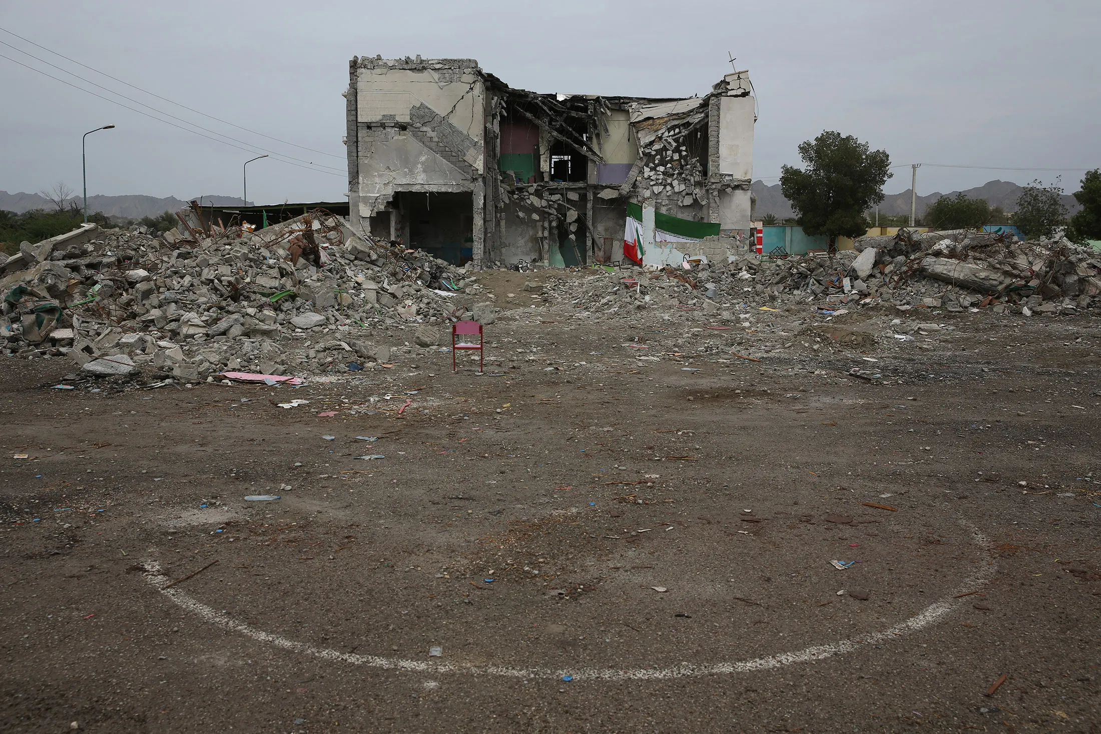
The Shajareh Tayyebeh primary school is seen after an airstrike in Minab on March 21. Photographer: Hassan Ghaedi/Anadolu/Getty Images
Micah Farfour, special adviser for remote sensing at Amnesty International, says the organization can no longer access Planet data, a primary source for ongoing investigations into military demolitions in Lebanon. Before the restrictions, Amnesty had used destruction and burn scars visible in Planet imagery to investigate the February airstrike on an elementary school in the Iranian city of Minab, which killed at least 150 children. In a world awash in artificial-intelligence-generated images and manipulated video, satellite imagery offers something rare, Farfour says: “It’s a very strong piece of truth in a lot of chaos.”